

Map Feature
Location! Location! Location!
I worked with a start-up to help design a comprehensive product from scratch. I was a part of researching for and creating a robust map tool. Its purpose is to help location scouts quickly and easily find potential locations for filming by using APIs and crowd-sourced information.
Overview

Helped to successfully bring a new product to market.
I was hand selected to work on a new product that fills a gap within a niche market. By understanding the needs of Location Scouts and the way they work, my team and I were able to create a map that gives them the tools and information they need to help them both find and monitor filming locations for their products. This significantly reduces the number of steps they need to take to effectively do their job and ultimately saves them time and effort.
Client - Locale Scout
The company was founded in order to create a tool for Location Scouts that did not previously exist. When I joined the team, based on their previous research, they knew creating a map was essential for the success of their project.
Team
Lacey Langlois, Delkash Shahriarian, Darrin Amellio, Kierstin Gray, Melissa Yanes, Geo Sosa and Aaron Hurvitz
My Role
My main focus was conducting UX research and working on wireframes that would inform the visual design process. I collaborated with a team that included: a product designer, subject-matter expert, several UX designers and a visual designer.
eKickoff
The Challenge
The biggest challenge was to create a new feature of a product that was still being developed and hadn’t been released to market yet. This meant we needed to start from scratch while our brand and identity were in the process of being developed.
In addition, We didn’t have a direct competitor to compare designs with, which meant we were working within a lot of ambiguity.
I teamed-up with another UX designer to create a map feature, which the company knew would be critical to the success of their product based on their previous research conducted with the users (Location Scouts). I needed to delve into the previous research completed and expand on it in order to create designs that add value.
Initial Assumptions
My team and I had initial assumptions that the users would be worried about this technology replacing their job instead of facilitating it.
We also assumed that many of our users would have been working in the field for a long time and may need some convincing to change the way they’ve been working for so long.
The Users
When I joined the project, there was already a clear picture of who the users were and what needs they had based on previous research and subsequent personas made before I joined the team. The main user group we focused on for our MVP was the professional Location Scout who needs to find specific shooting locations for major motion pictures or TV shows.
Initial Research

A snapshot showing a portion of the comparative analysis I put together.
Comparative Analysis
I did a comparative analysis of other map tools in order to see what information they contained and how that information was disseminated, This helped me determine what type of information users expect on map.

Questions Location Scouts Must Find Answers To
First, I worked with a partner to look through the findings from all the previous research done before I joined the team. We took note of information that’s valuable to Location scouts and created categories. Within each category, we made a list of questions Location Scouts would need answers to when doing their job.
We ended up with quite a lot of information and scope creep started to seep in. We wanted our feature to answer all or most of the questions, but we knew this wasn’t in the scope.
Fighting Off Scope Creep

Scope Creep had a mission, my team and I made sure it wouldn’t complete it!
What we wanted to do
The long-term vision of the map tool we were creating was to:
Inform whether or not a location could be a good fit for Location Scouts’ shoot
Give Location Scouts critical updates about their location of interest leading up to the day of the shoot. (For example, if a road in the vicinity of their location was shut down, this could potentially impact their shoot and would be valuable information for them).
What was feasible to do to remain within scope
With this in mind, we needed to scope down the project in order to deliver designs for a map feature within the timeframe we were given. This is why we scoped it down to focus on this particular task:
Create a map that helps location scouts make the initial decision “Is this location worth consideration from the director for my project?” We want users to make a quick “yes” or “no” decision when compiling places that are worth their while.
Create a map that focuses on New York for the MVP
To do this, we grabbed the information they would need to shortlist a location for a movie before showing it to the director.
I narrowed down the scope by focusing on the information a Location Scout would need to create an initial shortlist of location options they can show the director at the start of a project.
First I had to determine what information would be on the location details page, and what would be on the map page I was working on.
Then we made a list of all the information a Location Scout would need in order to shortlist location options to show the director.
Union zoning- Due to union requirements in some cities, if film staff and crew need to drive a certain distance, this will lead to higher expenses for the production company. We needed to show a 25-30 mile radius based on a central point of interest.
If an area has filming or parking permit restrictions--taking the location out of the running
Alerts that warn location scouts of disturbances that can impact shooting (noise, access, light, etc)
Area insights
what’s nearby the location to house crew, cater food, setup make-up and costume and shoot other scenes in the movie
Other locations in the vicinity that can also be used to shoot a scene for the project
Where will we get our information?
Now that I knew what type of information I needed, I looked into where the content would come from.
First my team and I looked at what information was already out there that we can pull into the map feature using APIs
We could bring in a lot of information from Google Maps, such as addresses and location details
Municipal websites for New York City had valuable information we could pull from, such as road closures, construction, etc.
Next we planned to have information crowdsourced. Since much of Location Scouts’ information on potential locations to shoot is from their own personal database, Locale Scout wanted to provide a place where that information could live. They could either house their information privately, only for their eyes, or share it publicly.

A list of potential NYC Municipal website my team and I could pull information from.
Comparing Visuals
Now that I knew what information would be included in the map MVP, the question was how to present it. Once again, I revisited other map tools to see how they presented information in a way that was clear, useful, and valuable. I took screenshots and made notes, represented in the images below.

Screenshot from Localize City
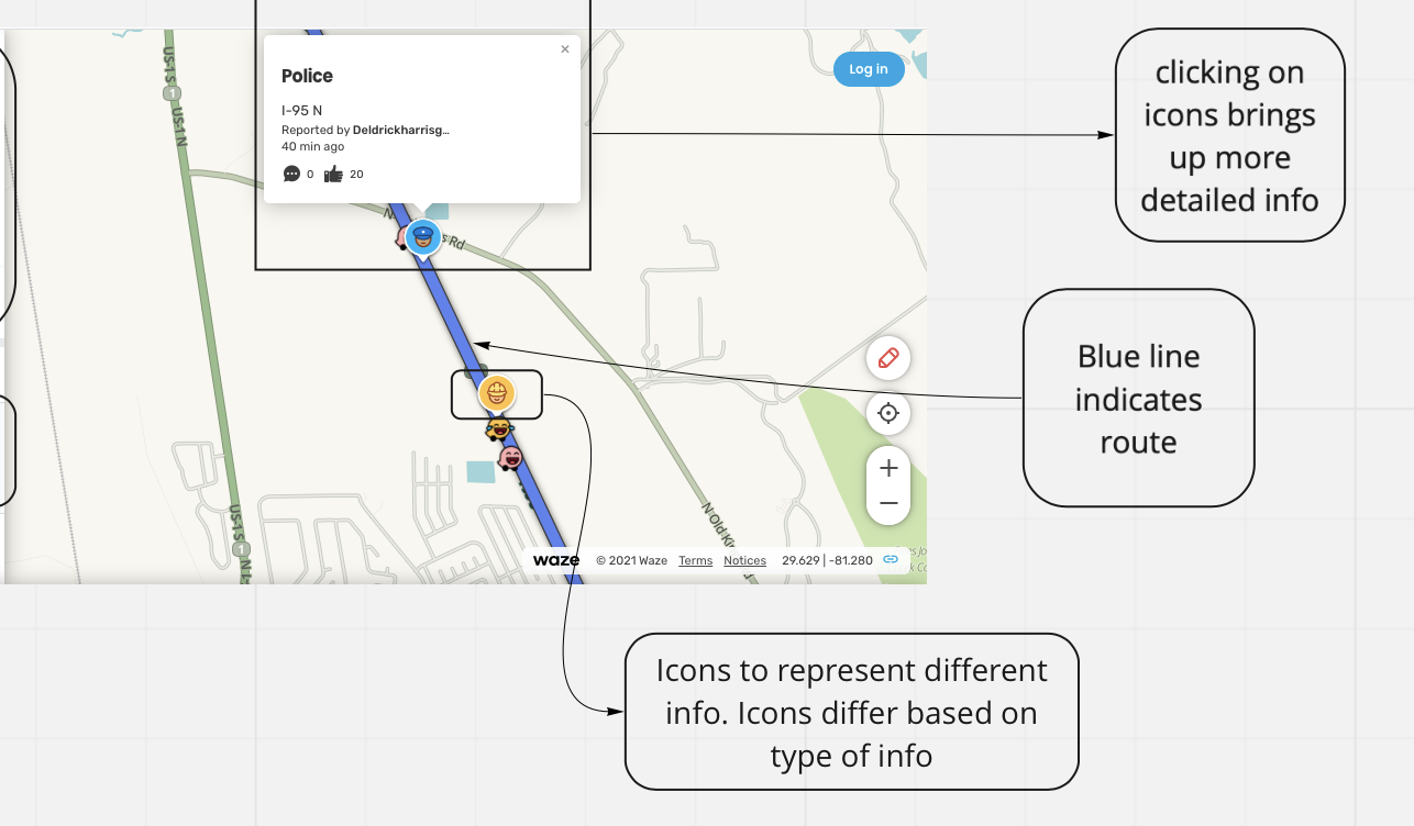
Image from Waze

Image from Google Maps

Image from Waze
Sketching
After the information architect on our team created a site map. I got to work on sketches for the map tool based on my research, thus far.


Wireframes
I worked with a partner to create preliminary wireframes before handing them off to Visual Design.


Next Steps
The Locale Scout team plans to conduct usability tests on this design and make the website live for users. I plan to be a part of this research and continuing to iterate on the map feature.
Conclusion
Overall, I empathized with Location Scouts in order to create a map feature that would significantly decrease the amount of time it would take them to shortlist potential locations for a shoot. A map tool catered to their specific needs did not previously exist. While we had to scope down the project to fit within our time frame, I plan to continue iterating on this feature in the future.